 Maths for Pilots
 Science for Pilots
 English Language for Pilots
 Verbal Reasoning for Pilots
 Numerical Reasoning for Pilots
 Mechanical Reasoning for Pilots
 ATPL Knowledge for Pilots
 WhatsApp
 Facebook Chat
 Email
Email


If you don't have time to read this article but would like to know whether our software can help - it can. You can buy access to our software and get started immediately, 365 days-a-year.
Buy Preparation SoftwareSpatial Awareness describes the ability to understand and reason about the positions, orientations and relationships of objects in space, including one's own position relative to other objects and reference points. In pilot aptitude testing, Spatial Awareness is assessed as the candidate's capacity to interpret instrument displays, determine aircraft orientation, understand directional relationships, and maintain an accurate mental picture of spatial position. Spatial Awareness is one of the most broadly assessed competencies in pilot aptitude testing, appearing as both dedicated modules and as a component within modules that primarily assess other skills. The specific spatial demands vary between modules, but collectively the types of spatial reasoning assessed include:
What distinguishes Spatial Awareness from the closely related skill of Spatial Transformation is the emphasis on understanding where things are in space rather than mentally manipulating or rotating them. Spatial Awareness tasks require the candidate to interpret positional information (Where is the aircraft? Which direction is it heading? Where is it relative to a beacon?) rather than to rotate, mirror or fold objects mentally. In practice, the two skills overlap considerably, and several modules assess both within a single task.
Further Reading on Spatial Cognition and its Components
The Structure of Spatial Ability
Research into spatial cognition has identified several distinct but related components. Spatial orientation refers to the ability to determine one's own position or the position of an object relative to other objects or reference frames. Spatial visualisation refers to the ability to mentally manipulate, rotate or transform spatial configurations. Spatial relations refers to the ability to recognise spatial patterns and relationships quickly [1].
Pilot aptitude tests draw on all of these components, but the modules classified under Spatial Awareness primarily assess spatial orientation: the ability to understand positional relationships between the aircraft, the ground, navigational aids and other traffic. This is distinct from Spatial Transformation modules, which primarily assess spatial visualisation (mentally rotating cubes, folding nets, or transforming perspectives). In practice, many test modules require elements of both, which is why several modules appear in both the Spatial Awareness and Spatial Transformation articles [2].
Spatial Awareness is exercised whenever you need to understand where you are, where something else is, or how to get from one place to another. Reading a map and relating it to your surroundings, giving directions to someone by describing landmarks and turns, or parallel parking a car by judging the distances between your vehicle and the cars in front and behind all require spatial awareness. In each case, the task involves building and maintaining a mental representation of how objects are arranged in space relative to each other and to yourself.
More demanding spatial awareness tasks arise when the reference frame changes. Following a route on a map that is not oriented with north at the top (for example, a map mounted on a wall that faces south) requires you to mentally reconcile two different orientations. Giving directions to someone who is facing the opposite direction requires you to reverse left and right in your instructions. Navigating through a building after studying a floor plan requires you to translate a two-dimensional bird's-eye representation into your three-dimensional, ground-level experience. These reference-frame challenges are directly analogous to the instrument interpretation tasks in pilot aptitude tests, where the candidate must reconcile the view shown on an instrument with the actual orientation of the aircraft in three-dimensional space.
Spatial Awareness is fundamental to safe flight. The pilot must continuously maintain an accurate mental model of where the aircraft is in three-dimensional space: its position relative to the ground, to terrain, to navigational aids, to other traffic, and to the intended flight path. Spatial disorientation, the loss of this mental model, is one of the leading causes of fatal accidents in both fixed-wing and rotary-wing aviation [3].
- Instrument interpretation and spatial orientation:
- When flying on instruments (in cloud, at night, or in reduced visibility), the pilot's primary source of spatial information is the instrument panel. The attitude indicator shows the aircraft's pitch and bank relative to the horizon, the heading indicator shows direction, and the altimeter shows height. The pilot must continuously translate these abstract, two-dimensional displays into a coherent three-dimensional picture of the aircraft's state. Misinterpreting an instrument, particularly the attitude indicator, can lead to spatial disorientation and loss of control. This skill is directly assessed by the Aon Spatial Orientation, COMPASS Orientation and CBAT Instrument Comprehension modules.
- Navigation and positional awareness:
- The pilot must maintain awareness of the aircraft's position relative to waypoints, airways, restricted airspace, terrain and the destination. This requires interpreting navigation displays, relating chart information to the real world, understanding bearings and distances, and projecting the aircraft's future position based on its current heading and speed. When using radio navigation aids (such as NDBs or VORs), the pilot must understand the angular relationship between the aircraft and the station, which involves the same kind of directional reasoning assessed in spatial awareness modules.
- Approach and circuit patterns:
- During a visual circuit or an instrument approach, the pilot must maintain spatial awareness of the aircraft's position relative to the runway, the approach path, and any terrain or obstacles. In a visual circuit, this involves judging distances and angles from the cockpit. On an instrument approach, it involves interpreting lateral and vertical guidance (localiser, glideslope, VNAV/LNAV) and maintaining awareness of the aircraft's position along the approach path. The ability to build and maintain this spatial picture under workload is critical to safe approach and landing operations.
- Traffic awareness:
- When receiving traffic information from ATC or observing traffic on a TCAS display, the pilot must understand where the traffic is relative to the aircraft: its bearing, distance, altitude and direction of travel. ATC traffic calls use clock-position references (for example, "traffic, two o'clock, three miles, opposite direction"), which require the pilot to translate a verbal description into a spatial picture relative to their current heading. This is a real-world application of the directional reasoning and bearing comprehension assessed in spatial awareness modules.
- Low-level navigation:
- Helicopter operations frequently involve low-level navigation in visual conditions, requiring the pilot to continuously relate their position to map features, landmarks, power lines, mast locations and terrain. This demands constant spatial updating: the pilot must track their position on the map, anticipate upcoming features, and maintain awareness of the surrounding terrain and obstacles. The rate of spatial updating is much higher at low level than at altitude, because the ground features pass more quickly and the margins for error are smaller.
- Confined area operations:
- Landing a helicopter in a confined area (such as a hospital helipad, an accident scene, or a ship's deck) requires precise spatial judgement: the pilot must assess the available space, judge approach angles, account for wind direction, identify obstacles and their heights, and maintain spatial awareness of the aircraft's position relative to all of these throughout the approach and landing. Misjudging any spatial element can result in a rotor strike, a tail strike, or a collision with an obstacle.
- Search patterns:
- During Search and Rescue operations, the pilot must fly systematic search patterns (such as expanding squares or parallel tracks) whilst maintaining awareness of the area already covered, the area remaining, and the aircraft's position within the pattern. This requires sustained spatial awareness over extended periods, combined with the ability to navigate accurately along the pattern legs whilst scanning for the search target.
Spatial disorientation occurs when the pilot's perception of the aircraft's position, attitude or motion does not correspond to reality. It is a leading cause of fatal accidents, particularly in instrument meteorological conditions and at night [3]. A pilot with strong spatial awareness is better equipped to detect and recover from disorientation because they can more accurately interpret instruments, recognise conflicting sensory cues, and maintain an accurate mental model of the aircraft's state even when visual references are absent.
By assessing spatial awareness during selection, test designers are evaluating a candidate's baseline capacity for the kind of spatial reasoning that underpins safe instrument flying. While all pilots are trained in instrument interpretation, the speed and accuracy with which a candidate can build spatial understanding from abstract instrument displays varies between individuals, and this variation is measurable through aptitude testing.
Modern cockpits provide extensive navigational information through moving map displays, FMS systems and GPS. However, the ability to understand spatial relationships, to know where the aircraft is, where it is going, and how its current position relates to terrain, traffic and the intended flight path, remains a cognitive skill that technology supports but does not replace. Automation failures, map display malfunctions, and situations requiring deviation from the planned route all demand that the pilot can reason spatially without relying solely on automated displays [4].
Spatial awareness also underpins the broader concept of situational awareness, which encompasses not just where the aircraft is but what is happening around it. Understanding the spatial relationships between the aircraft, weather, terrain, traffic and the planned route is a continuous cognitive demand that operates throughout every phase of flight.
Spatial Awareness appears across Aon (Cut-e), CBAT / CFAST / MACTS, COMPASS, Advanced COMPASS and DLR assessments, making it one of the most widely assessed skills in pilot aptitude testing. Several modules assess spatial awareness as their primary focus (Aon Spatial Orientation, COMPASS Orientation), whilst others incorporate spatial awareness as a component alongside other skills such as numerical reasoning, mathematics, motor control, multitasking or spatial transformation. This breadth reflects the pervasive role of spatial cognition in aviation, where the ability to understand positions, directions and relationships in space supports virtually every aspect of flight operations.
Further Reading on Spatial Ability and Pilot Selection
Spatial Ability as a Predictor of Flight Training Success
Meta-analyses of pilot selection research have consistently identified spatial ability as one of the strongest cognitive predictors of flight training success [5]. The predictive relationship is particularly strong for the flight training phase (as opposed to ground school), which makes intuitive sense: the cognitive demands of actually flying an aircraft, particularly on instruments, are heavily spatial in nature.
Research has also shown that spatial ability is relatively stable across adulthood and is partially distinct from general intelligence, meaning that it captures variance in performance that is not accounted for by general cognitive ability alone [1]. This is why spatial ability tests have remained a core component of pilot selection batteries since the earliest systematic selection programmes in the 1940s, and why they continue to feature prominently in modern computerised assessment systems.
Computerised pilot aptitude tests evaluate Spatial Awareness using tasks that require the candidate to interpret spatial information, determine orientations and positions, and reason about directional relationships. Many modules use aviation-themed scenarios (instrument displays, aircraft positions, navigation problems), giving them high face validity for pilot selection. Spatial Awareness is assessed both as a dedicated skill and as a component within modules that combine it with other competencies.
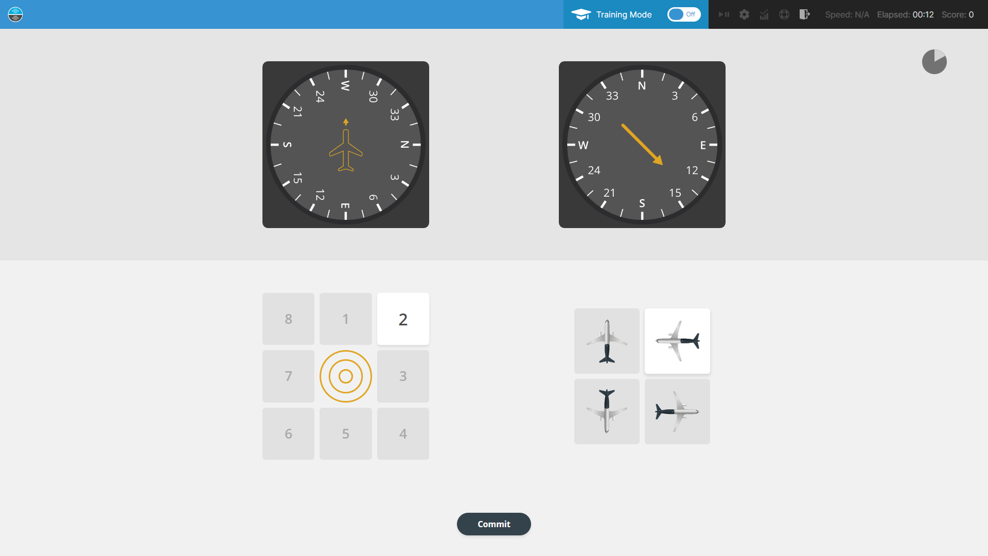
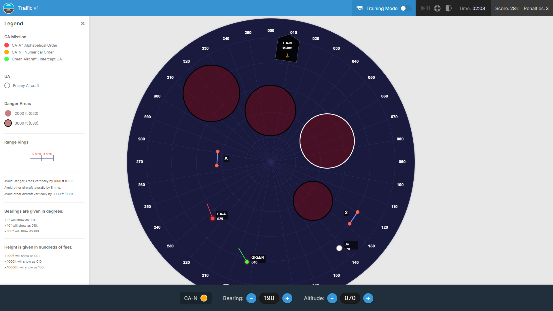
Instrument-based orientation modules present the candidate with simulated aircraft instruments and require them to determine the aircraft's position, heading or attitude. The Aon Spatial Orientation (scales ndb) module displays a Direction Indicator (DI) and an Automatic Direction Finder (ADF), and the candidate must identify which aircraft (from a selection) corresponds to the position and heading shown relative to a Non-Directional Beacon (NDB).
The COMPASS and Advanced COMPASS Orientation modules present three instruments: a Direction Indicator, an Artificial Horizon and a Relative Bearing Indicator (RBI). The candidate must interpret all three instruments simultaneously to determine the aircraft's heading, attitude (pitch and bank) and position relative to a beacon, then select the matching aircraft from the options provided. These modules require the candidate to integrate multiple spatial cues into a single coherent picture, which directly mirrors the real-world demand of interpreting an instrument panel during flight.
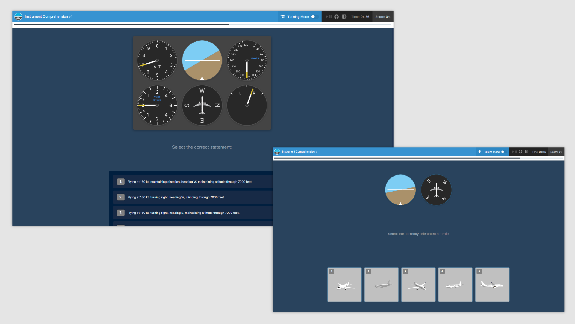
The CBAT Instrument Comprehension Test (INSC) requires the candidate to interpret standard aviation instruments and match them accurately with three-dimensional images and accompanying statements. This module assesses both spatial awareness (understanding what the instruments indicate about the aircraft's position and orientation) and spatial transformation (translating two-dimensional instrument displays into a three-dimensional spatial picture).
The INSC module is distinctive in requiring the candidate to bridge between two-dimensional instrument representations and three-dimensional spatial understanding, a cognitive demand that is central to instrument flying. This makes it one of the most aviation-specific spatial awareness assessments in current use.
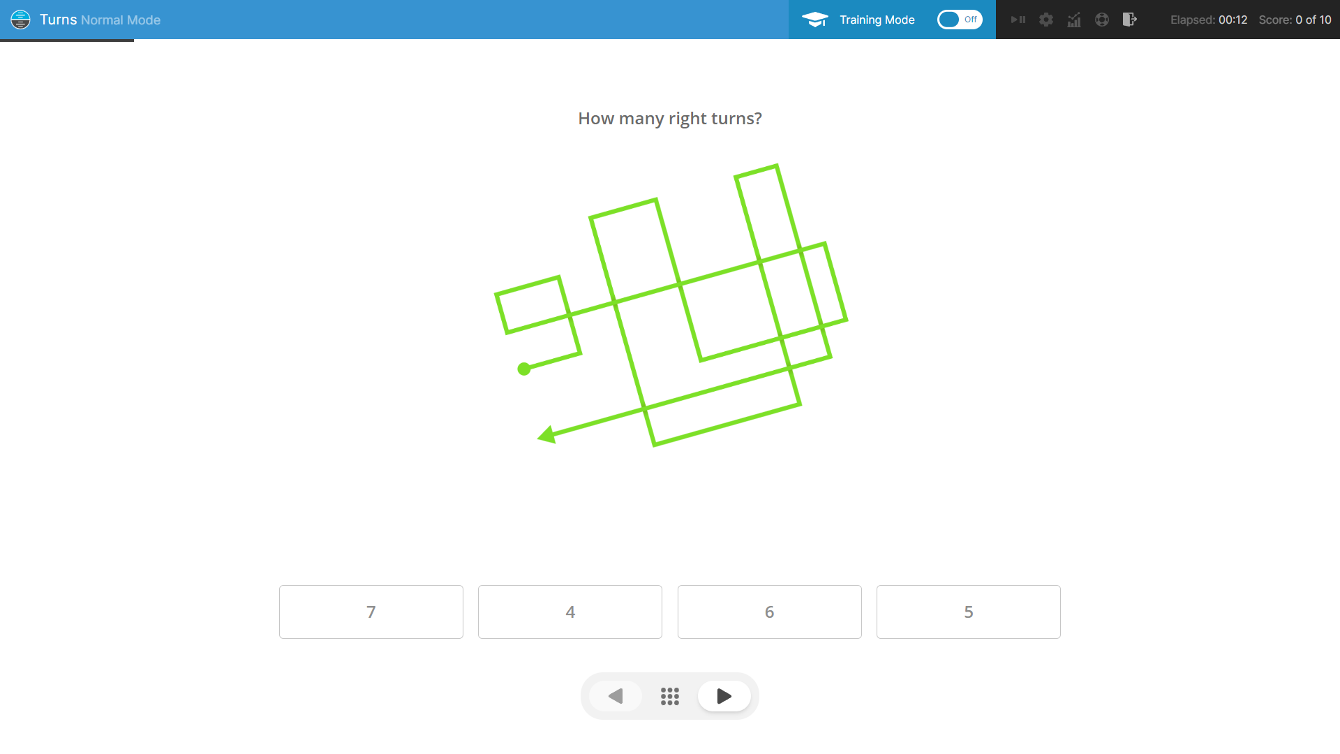
The DLR Path Figure Test (WFG) presents randomly generated line drawings depicting the start and finish of a route. The candidate must examine the route and correctly identify the number of left or right turns it contains. This requires the candidate to mentally trace the path, maintaining spatial orientation as the direction of travel changes with each turn.
This module assesses both spatial awareness (tracking direction of travel through a series of turns) and spatial transformation (mentally tracing a route and determining orientation at each point). The task becomes more demanding as routes include more turns, because the candidate must track cumulative directional changes without losing their sense of the current heading. This module also appears in the Spatial Transformation article.
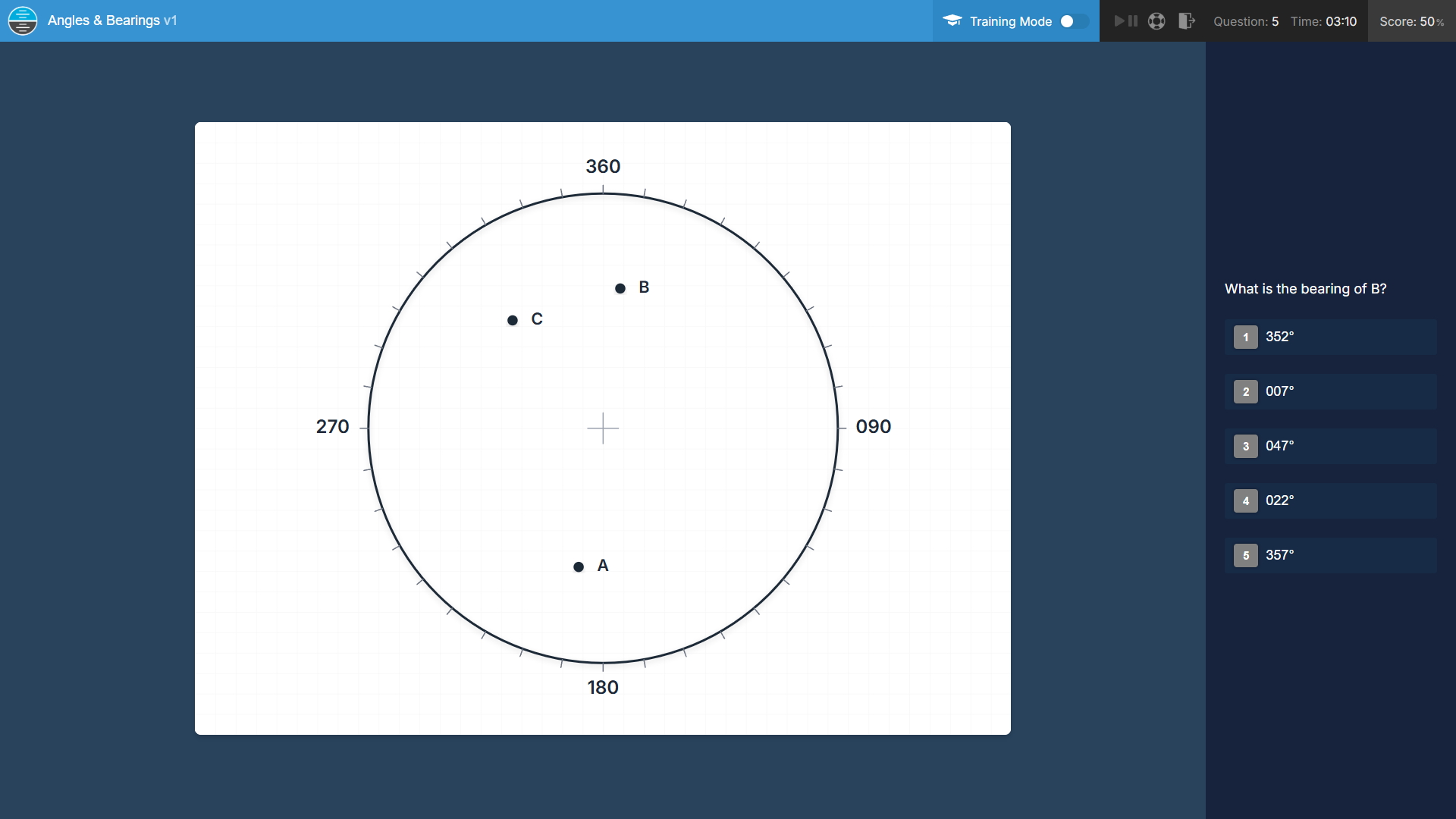
Several CBAT modules incorporate spatial awareness within navigation and mathematical contexts. The Angles, Bearings & Degrees Test (ABD) requires the candidate to estimate angles, bearings and degrees displayed in two-dimensional diagrams under time pressure. The Airborne Numerical Test (ANT) requires the candidate to examine route-based information from multiple sources and calculate answers using speed, distance and time equations, combining numerical reasoning with spatial interpretation of route data.
These modules assess the candidate's ability to reason spatially about directions, angles and routes, skills that underpin aviation navigation. Understanding bearings, estimating angles, and interpreting route information are daily tasks for pilots, whether planning a flight, interpreting a chart, or responding to vectoring instructions from ATC.
Some modules assess spatial awareness in dynamic contexts where positions change over time. The CBAT Dynamic Projection Test (DPT) requires the candidate to manage the flight of multiple aircraft from a top-down perspective, tracking trajectories and making timely decisions. The CBAT Rapid Tracking Test (RTT) requires the candidate to observe and capture imagery of moving targets, demanding sustained spatial awareness alongside motor control. The Aon Working Memory (gridChallenge) module requires memorisation of dot positions on a spatial grid, combining spatial awareness with memory recall.
These dynamic modules assess the candidate's ability to maintain and update spatial information in real time, which is directly relevant to the operational demands of traffic awareness, trajectory prediction, and maintaining situational awareness in a changing environment.
Spatial Awareness is assessed in the following pilot aptitude test systems:
The table below outlines the modules that assess Spatial Awareness in each test system, linking each to the relevant preparation activity in our software. Several modules assess spatial awareness alongside other skills; these are included because their spatial demands are significant and preparation for the spatial component will improve overall performance.
| Assessment | Module | Skills Assessed | Format | Activity |
|---|---|---|---|---|
| Aon (Cut-e) | Spatial Orientation (scales ndb) | Spatial Awareness | Infinite, 3 min | Direction |
| Aon (Cut-e) | Working Memory (gridChallenge) | Spatial Awareness + Memory | Infinite, 9 min | Switch |
| CBAT / CFAST / MACTS | Instrument Comprehension Test (INSC) | Spatial Awareness + Transformation | TBC | Instrument Comp. |
| CBAT / CFAST / MACTS | Angles, Bearings & Degrees Test (ABD) | Mathematics + Spatial Awareness | TBC | Angles & Bearings |
| CBAT / CFAST / MACTS | Airborne Numerical Test (ANT) | Numerical Reasoning + Spatial Awareness | TBC | Routes |
| CBAT / CFAST / MACTS | Dynamic Projection Test (DPT) | Multitasking + Monitoring + Spatial Awareness | TBC | Traffic |
| CBAT / CFAST / MACTS | Rapid Tracking Test (RTT) | Motor Skills + Monitoring + Spatial Awareness | TBC | Scout |
| COMPASS | Orientation | Spatial Awareness | 16 questions, 10 min | Bearings Bearings Lite |
| Adv. COMPASS | Orientation | Spatial Awareness | 16 questions, 10 min | Bearings Bearings Lite |
| DLR | Path Figure Test (WFG) | Spatial Awareness + Transformation | 16 questions, 10 min | Turns |
Having identified the modules relevant to your assessment, you can navigate directly to the corresponding activities within our software.
Our software organises activities by the type of assessment you are preparing for, the skill being evaluated, and the specific airline, flying school or cadet scheme you are applying to. This means you do not need to manually cross-reference the table above; the relevant Spatial Awareness activities will already be included in your tailored preparation.
To find the activities relevant to you, navigate to one of the following within the software:
- Activities by Aptitude Test
- If you know which test system your assessment uses. For example, to find Spatial Awareness activities for COMPASS, navigate to Activities by Aptitude Test and select COMPASS.
- Activities by Skill
- If you want to focus specifically on Spatial Awareness across all test systems. Navigate to Activities by Skill and select Spatial Awareness to see every relevant activity.
- Activities by Airline, Flying School or Cadet Scheme
- If you know where you are applying but not which test system is used. Navigate to Activities by Airline or Activities by Flying School and select your chosen organisation. The software will include the appropriate Spatial Awareness activities alongside all other relevant preparation.
If you have created a Preparation Strategy, the relevant Spatial Awareness activities will already appear in your Focus Activities; no additional navigation is required.
Spatial Awareness is closely associated with several other competencies assessed in pilot aptitude testing. Candidates preparing for Spatial Awareness modules may also benefit from developing the following related skills:
Academic Sources referenced in this KB Article
The following academic sources were consulted in the preparation of this article:
[1] Carroll, J. B. (1993). Human Cognitive Abilities: A Survey of Factor-Analytic Studies. Cambridge University Press.
[2] Lohman, D. F. (1979). Spatial ability: A review and reanalysis of the correlational literature. Technical Report No. 8. Stanford University, Aptitude Research Project.
[3] Gibb, R., Ercoline, B., & Scharff, L. (2011). Spatial disorientation: Decades of pilot fatalities. Aviation, Space, and Environmental Medicine, 82(7), 717-724.
[4] Endsley, M. R. (1995). Toward a theory of situation awareness in dynamic systems. Human Factors, 37(1), 32-64.
[5] Hunter, D. R., & Burke, E. F. (1994). Predicting aircraft pilot-training success: A meta-analysis of published research. The International Journal of Aviation Psychology, 4(4), 297-313.

With a section dedicated to Spatial Awareness, our one-of-a-kind software represents the ultimate way for you to get prepared.
By leveraging our cutting-edge software, including those unique features and extensive guidance not offered elsewhere, you can immerse yourself in realistic simulations, master those competencies assessed, and familiarise yourself with the methods and mechanisms of assessment.
Our software is backed by our meticulous attention to detail and deep expertise as experienced commercial pilots, empowering pilot applicants to approach their assessments with confidence and helping to propel them to supersonic levels of success.
Start using our incredible preparation software immediately on PC, Mac, iOS and Android by purchasing a subscription:
Buy Preparation SoftwareWith increasing prevalence and awareness of computerised pilot aptitude testing in pilot assessments, it's never been more important to ensure that you can fly past the competition. This is made easy with features unique to our software:


Discover the key advantages of using our cutting-edge software:
How can I prepare for my Spatial Awareness pilot assessment?
The best way to prepare for your Spatial Awareness pilot assessment is with our latest industry-leading software, developed over 5 years by experienced airline pilots. With realistic exam simulations, personalised Preparation Strategies which guide you through your preparation, immersive Explainer Videos, customisable Training Modes that manipulate your simulation environments, comprehensive Instruction and Guidance, and extensive performance feedback which incorporates unique features such as Predictive Scoring, a Strength & Weakness Map and Colour Coding, our unique software will help you to accelerate improvement of your problem areas and fly through each part of the Spatial Awareness assessment. The software runs in a web browser, is compatible with laptop, desktop, tablet and smartphone, and is complimented with extensive support, provided from 9AM to 9PM GMT. To purchase a subscription to our software and start preparing for your Spatial Awareness pilot assessment, click here!
What is the pass mark for the Spatial Awareness pilot assessment?
Many pilot aptitude tests do not have a fixed threshold (or pass mark), but rather indicate the pilot candidate's overall performance and suitability using a variety of different methods - many of which are emulated within our software. Rather than worrying about a specific pass mark, the better approach is to focus on comprehensive preparation that maximizes your chances of success within each part of the Spatial Awareness pilot assessment. Our industry-leading pilot preparation software provides that comprehensive preparation, helping you to develop the essential sklls, familiarity with assessment and confidence needed to perform at your best. If you have any questions about the Spatial Awareness pilot assessment, please contact us.
How often is your Spatial Awareness assessment preparation software updated?
Our pilot assessment preparation software is continuously updated, with daily improvements based on feedback from hundreds of monthly users. Developed by experienced airline pilots, the simulations provided within our unique software faithfully reflect the Spatial Awareness pilot assessment, ensuring that you have the most current and comprehensive preparation. To see the recent updates to our preparation software, please visit our Updates page.
What support is available with your Spatial Awareness assessment preparation software?
With our own industry experiences, we understand the pressures and stresses that come with preparing for pilot assessments. When you use our software to prepare for your Spatial Awareness pilot assessment, you'll have access to exceptional support and guidance from our team of experienced airline pilots, provided between 9AM and 9PM GMT. This support sets us apart, helping you to develop the skills, knowledge, and confidence needed to approach your assessment feeling completely ready to demonstrate your true potential and fly past the competition at every stage of the Spatial Awareness pilot assessment.
How quickly can I prepare for my Spatial Awareness pilot assessment with this software?
If you'd like to start preparing for the Spatial Awareness assessment, you may start using our software within as little as a few minutes. We offer access to our preparation software for 7 days, 1 month or 3 months, and provide the opportunity to purchase additional time. This ensures you can work through the comprehensive simulations, and benefit from our guidance at your own pace, with support available whenever you need it. To get started, choose a subscription duration to our preparation software, create an account and complete your purchase - then, login and begin your preparation. The entire process typically takes between 2-3 minutes, with secure payment by credit or debit card securely processed with Stripe or PayPal.
Feature-packed and one-of-a kind preparation software for your assessment.
Regularly updated, realistic and infinite simulations of aptitude tests.
Instant activation, fast support and uniquely in-depth guidance.